Last updated on: January 2, 2025
Table of Contents
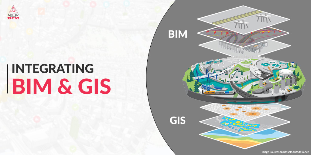
Connecting BIM and GIS
BIM (Building Information Modeling) and GIS (Geographic Information System) are two technologies with specific purposes and use. GIS has mapping features and geographical databases, while BIM is specifically used for building assets as an object-based information model. The connecting link between these two technologies is gaining credibility in complex and large-scale projects. Architectural and civil engineering projects usually make use of BIM technologies while environmental projects are traditionally done using GIS systems.
In this blog, we will learn about all the benefits and differences between GIS and BIM technologies and their uses.
Don’t have the time to read the whole blog, no worries you can download it and read it at your convenient time.
What is BIM?
3D depiction of Physical and functional characteristics of building assets.
BIM provides an integrated database for the building and infrastructure assets that includes a 3d representation of physical & functional characteristics and geometrical data of the associated assets. It is a resource of information that is shared and that supports document management, trade coordination, team collaboration, and 4D construction sequencing. It helps in decision-making throughout the project life cycle.
BIM Software: Revit, Navisworks, AutoCAD 3D, Civil 3D, and others
Read more about What is Building Information Modeling (BIM)?
What is GIS?
2D & 3D representations of geospatial shapes
GIS provides information about natural and built environmental assets and other crucial factors considering geography, demography, social economy, and environment. It is a system that collects, creates, integrates, manages, analyzes, and visualizes spatial data using maps. It helps users understand patterns, spatial relations, and geographic context. Ultimately, it helps efficient decisions about the facility management and operation & maintenance of those assets.
GIS Software: ArcGIS, CityGML, Bentley Maps, and others

BIM and GIS
GIS informs BIM by providing the real-time data of an asset’s existing environment which helps designers and engineers to explore and evaluate the design and construction. Furthermore, an information-rich model can be used to improvise all the assets within a larger area for operations and maintenance.
Integration of BIM and GIS builds a robust model where geographic and infrastructural design information are compiled together to ease the understanding of asset’s interaction and relation within geography.
Application of BIM-GIS Integration
The developed BIM GIS model includes all information about utility infrastructure used during the planning, design, construction, and operation stages. The applications of BIM to GIS integration are the following:
- Visualization
The BIM vs GIS platform provides the geometric 3D visualization of each component that contains geometric information and semantic information. The visualization facilitates project planning and execution. The visualization of geographic terrain, details on the terrain, surrounding facilities, and ground and underground infrastructures can be realized in the GIS environment.
- Facility Management
Operations and maintenance work are required either due to the failure of utilities or according to routine schedules. The BIM-GIS integrated model provides ready to us information about the utilities that can be used by the operation and maintenance team to identify the location, types, and material. Readily available information about the utility, making the system effective, reduces time delays and cost overruns.
- Clash Detection
Renovation and repair activities are common during the operation stages. Traditionally, the utility information is either unavailable or is available in 2D CAD drawings. It is very difficult to extract the exact utility information from 2D drawings that cause a potential clash between the utilities. In this BIM-GIS integrated platform, many BIM tools such as Civil 3D, Navisworks, and GIS tools such as ArcGIS provide capabilities for clash detection between the 3D utility model. The 3D model helps in providing information that will help in further actions.
Does your project require Underground Utility Locating Services and BIM Modeling Services? Please feel free to reach out to us via call at +1(860) 317-7105 or drop us an email at info@united-bim.com

BIM GIS based Underground Utility Management System
| Qualitative Metrix | Traditional Underground Utility | BIM-GIS Based Integrated Framework |
| 2D Visualization | Yes | Yes |
| 3D Visualization | No | Yes |
| Quantity take-off | Manual | Automated |
| Material Information | Basic | Detailed |
| Data Sharing | Manual | Automated |
| Excavator Operator Visualization | No | Yes |
| Utility Clash Analysis | Manual (hard) | Automated (easy) |
| Design Change | Manual | Automated |
| Facility Management | No | Yes |
Benefits of BIM and GIS Integration
- Maximize the returns from existing investment in BIM & GIS software
- Advance the understanding of highly detailed geospatial context
- Enable collaborative workflows that ease the data reuse for all the parties involved
- Make better-informed decisions to accelerate project delivery and improve the operations and maintenance of completed assets.
- Help architects, engineers, and GIS teams work together more effectively to put data at the center, remove silos, and connect workflows.
- Enable architects and engineers to design smarter, more efficient buildings and infrastructure.
- Collect and analyze data from the field and improve communication with key stakeholders.
- Connect existing systems of record to create a federated source of truth that helps minimize costly errors and delays regarding critical design decisions.
Adopting 3D BIM processes and GIS technologies will largely benefit the environment and remediation industries. It will open the door for more inclusive stakeholder engagement, better design quality, and data-driven decision-making. Integration of BIM and GIS provided more holistic and integrated workflows in the AEC industries to reduce cost and meet growing demand.
Explore our BIM Services
ReferencesAbout the Author

Coordination Manager / VDC Manager at United BIM
With over 10 years of experience in the AEC industry, Akash Patel is a seasoned Coordination Manager and VDC Manager at United BIM. His expertise lies in managing complex MEP-FP coordination projects and leveraging cutting-edge BIM technology to ensure seamless collaboration and precision. Akash is dedicated to delivering high-quality, detailed models that meet the demands of modern construction. He is passionate about optimizing workflows and driving innovation within the BIM field.