Scan to BIM Services in USA | Accurate Point Cloud to BIM Modeling
Turn your laser scan data into precise BIM and CAD models with United-BIM. Our Scan to BIM services in the USA deliver accurate and parametric as-built 3D BIM models and 2D CAD drawings that capture every detail from walls, slabs, MEP systems, roof plans, facades, to site layouts.
United BIM’s Point Cloud Scan to BIM Modeling Services
Our Point Cloud to BIM services focus on delivering precise, detail-rich models you can rely on for planning, estimation, coordination, and execution. With proven expertise in handling both laser survey images and point cloud data, we ensure that your project starts with a solid digital foundation.
Years in Business
Sectors
Projects
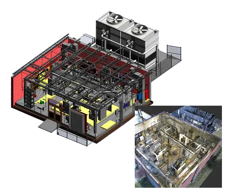
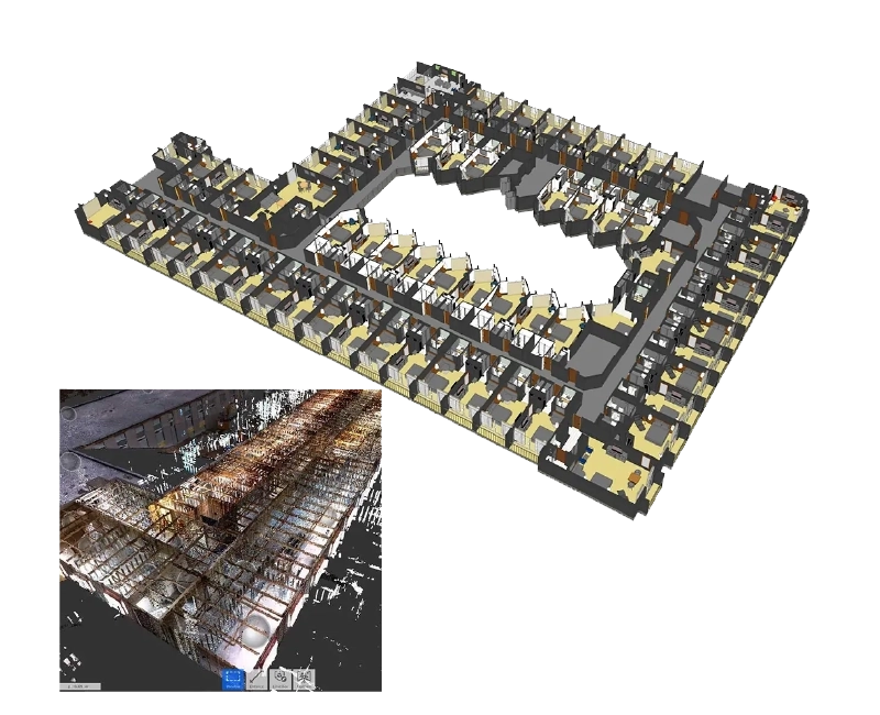
Some of our Scan to BIM Projects in USA


Our Scan to BIM Process
With over a decade of experience in the BIM industry and hundreds of successful projects delivered, we know that a well-structured process is what makes the difference. Our workflow ensures accurate, consistent, and error-free deliverables:
- Import and process point cloud scan data (.RCP, .RCS, .FLS, .E57, .OBJ, .PCG) into Revit-ready environments
- Establish project levels, grids, and reference systems for modeling
- Develop Architectural, Structural, and MEP elements directly from point cloud geometry
- Validate model accuracy against scan data to maintain defined tolerances
- Deliver BIM models (.RVT) and CAD drawings (.DWG) with complete annotations, dimensions, and layering
We specialize in converting laser scans into models that cover Architectural, Structural, and MEPFP elements, including:
- Architectural : Walls, doors, windows, cabinets, interiors
- Structural : Beams, columns, foundations, framing, trusses
- MEPFS : Electrical panels, junction boxes, ducting, piping, air terminals, fire sprinklers
- Revit MEP Coordination: Clash detection with Autodesk Navisworks
Why Choose Our Scan to BIM Services
At United BIM, we focus on precision, scalability, and real-world usability of BIM models. Our team of BIM modelers and CAD experts converts point cloud data into highly accurate 3D BIM models and as-built 2D drawings aligned with project-specific LOD and standards.
All we require is point cloud scan data and project standards, and we deliver:
- Accurate point cloud to BIM conversion aligned with site conditions
- LOD-based BIM models (LOD 100 to LOD 500)
- Detailed as-built 2D drawings with annotations and layering
- Models ready for coordination, clash detection, and downstream workflows
- On-time delivery with scalable team support
We also collaborate with trusted laser scanning partners across the USA when scanning support is required.
We promise to deliver
- Accurate reproduction of point cloud scan
- 3D BIM models with required LOD 100 to 500
- As-built 2D drawings with dimensions, annotations, layering
- On-time delivery
Application of Our Scan to BIM Modeling Services
- Renovation, Retrofit, and Refurbishment Projects
- Reconstruction and Facility Management
- Commercial, Residential, and Industrial Projects
- Infrastructure projects including roads, bridges, and tunnels
Levels of Detail (LOD) We Deliver
We provide the following Level of Documentation for our clients:
- LOD 100 – Conceptual
- LOD 200 – Approximate geometry
- LOD 300 – Accurate geometry
- LOD 350 – Interface detailing
- LOD 400 – Fabrication level
- LOD 500 – As-built conditions
We have experience of developing both Revit (.rvt) and CAD (.dwg) files from different formats of scans or point cloud data usually captured by commonly used laser scan machines— Leica Geosystems, Trimble, Faro Scanners, Reigl scanners. We also convert other format data (i.e. .fls, .e57, .pcg. .obj, .ptg) into Revit-ready format. We create information-rich BIM Ready 3DModel for Architectural, Structural, and MEPFP Requirements, and Clash-free integration.
Location We Delivered Our BIM Services
USA

Contact Us

Architects, engineers, contractors, facility managers, and owners use Scan to BIM for renovation projects, facility management, heritage preservation, and MEP coordination.
We mainly use Autodesk Revit, along with tools like Recap, Navisworks, and other BIM coordination platforms
Our Scan to BIM models are developed with a typical accuracy range of ±5mm to ±15mm, depending on the quality of the point cloud data and project requirements. We follow strict validation workflows to ensure the BIM model aligns closely with real-world site conditions.
The cost of Scan to BIM services depends on several factors, including project size, level of detail (LOD), complexity, and quality of scan data. After reviewing your point cloud data and requirements, we provide a clear and customized quote aligned with your project scope.
Yes. While our core expertise lies in Scan to BIM modeling and point cloud to BIM conversion, we also support LiDAR and 3D laser scanning services through our trusted partner network across the USA, enabling a complete end-to-end solution when required.
We support a wide range of projects, including:
• Renovations, restorations, and retrofits
• Commercial and residential upgrades
• Industrial facilities and plants
• Historic and heritage building documentation
Our Scan to BIM services are tailored to deliver accurate as-built models for each of these use cases.
Yes. We provide Scan to BIM services across the USA, supporting clients remotely by working with their point cloud data. We also coordinate with local laser scanning partners when on-site data capture is required, ensuring seamless project execution nationwide.